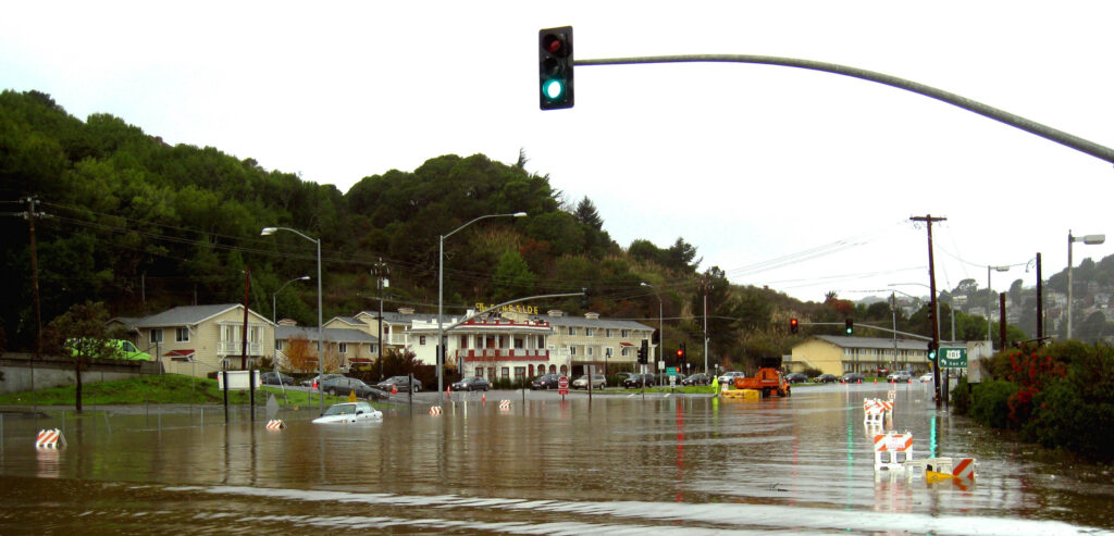
San Rafael, CA – During the hot summer months, it can be easy to forget that the winter brings rain and flooding to Marin County. Tide-related flooding can happen whether it is raining or not, but the flooding can increase significantly if elevated tides occur during a storm. Seasonal high tides, sometimes referred to as king tides, tend to cause flooding along shoreline communities and some low-lying roads in Marin County, potentially impacting commute times and travel plans.
Based on tide predictions from the National Oceanic and Atmospheric Administration (NOAA), tide levels that could be high enough to cause roadway flooding in coastal and bayside areas of Marin are expected November 13-18, December 11-17 and 30-31, as well as January 1 and 28-30. If a storm happens during those times, it tends to cause tidal surges which can push water levels significantly higher than predicted.
Coastal communities and areas historically susceptible to flooding have a higher chance of being impacted. That can be most prevalent in areas of Marin where signs of sea level rise are already increasing tidal flooding issues during seasonal king tides. Some of those locations are North San Pedro Road through China Camp in unincorporated San Rafael, Greenwood Cove Drive in Tiburon, Lucky Drive in Greenbrae, Redwood Highway at Greenbrae Boardwalk, Marin City, and the Manzanita Park & Ride lot (a Caltrans property) near Tam Junction.
The Marin County Department of Public Works and the Marin County Flood Control and Water Conservation District are urging residents and visitors to be aware of the predicted king tides. Drivers should allow extra time for trips and be prepared to use alternative routes to avoid localized flooding on roadways. Travelers should always avoid driving through standing water, as even six inches of depth can stall a vehicle.
Residents are encouraged to plan ahead and take action on their own property to help reduce flood risk. In advance of all storms, it is recommended that residents clear dead leaves from driveway pipes, rooftop gutters, and storm drains on their private property. Dead foliage needs to be placed in compost bins, not put in streets where it will clog neighborhood drainage systems. Those living in flood-prone areas should test their sump pumps and stock up on sandbags (available at most hardware stores), as well as learn how to properly use them prior to storms. Additionally, ReadyMarin.org provides detailed resources, including emergency grab-and-go packing checklists, that can be helpful for residents to prepare for the unexpected.
The following list shows predicted high tides at or above 6.4 feet from November 2024 through January 2025 at the San Francisco tide gauge.
2024:
November 13, 8:51 AM, 6.4 feet
November 14, 9:26 AM, 6.7 feet
November 15, 10:04 AM, 7.0 feet
November 16, 10:43 AM, 7.0 feet
November 17, 11:26 AM, 6.9 feet
November 18, 12:11 PM, 6.6 feet
December 11, 7:32 AM, 6.4 feet
December 12, 8:12 AM, 6.7 feet
December 13, 8:54 AM, 7.0 feet
December 14, 9:37 AM, 7.1 feet
December 15, 10:22 AM, 7.0 feet
December 16, 11:08 AM, 6.8 feet
December 17, 11:54 AM, 6.5 feet
December 30, 10:11 AM, 6.4 feet
December 31, 10:53 AM, 6.4 feet
2025:
January 1, 11:35 AM, 6.4 feet
January 28, 9:58 AM, 6.5 feet
January 29, 10:42 AM, 6.5 feet
January 30, 11:28 AM, 6.4 feet
Travelers can check 511.org for latest traffic and transit information. During storm events, DPW’s Twitter/X, Marin County Sheriff’s Office’s Twitter/X, the California Highway Patrol (CHP) traffic website and CHP Marin’s Twitter/X are all excellent resources for travelers and residents looking for updates.
Another vital resource for residents is the Marin County emergency portal, which provides a range on helpful information and links. Alert Marin, operated by the Marin County Office of Emergency Management, is another important system for residents to sign up for (and their update contact information), as it provides critical notifications during emergencies. For residents interested in data, weather gauges showing rainfall amounts can be viewed in real-time at Marin County’sOneRain webpage. Additionally, during a storm event, residents can call 415-473-6530 to be routed to the respective department to address the resident’s concerns.
Leave a Reply